Early Settlement in Rattray

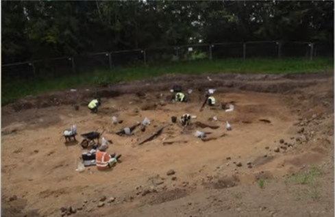
Photo courtesy of TAFAC
Early Settlement in Rattray
Did you know Rattray was here 4000 years ago?
We were amazed to hear that back in around 2000 BC(BCE) there was a settlement where Rattray now sits!
c2000 BC(BCE)
EARLY SETTLEMENT IN RATTRAY
In 2021 an archaeological investigation commissioned by G.S.Brown, Construction, involving GUARD Archaeology and Perth and Kinross Heritage Trust was carried out on an area of land in the Honeyberry area of Rattray, Perthshire. There is clear evidence that people were living in this area from around 4000 years ago, building round houses of the Bronze Age type found elsewhere in Scotland, creating and using pottery and using metal working methods to fashion tools and weapons.Further analysis will be carried out on specimens and artefacts from the site to give more details, but, for now, click on this link to watch a video by Tayside and Fife Archaeological Committee (TAFAC) and GUARD Archaeology Ltd:
https://www.youtube.com/watch?v=F1B7nSh_pHI
Before this momentous archaeological revelation in November 2021, what was known of Rattray's past?
It was thought that Rattray existed before Blairgowrie. Since the oldest part of Blairgowrie is believed to be the area around Kirk Wynd, which at the outset would have been a cluster of cottages, possibly dating from the Middle Ages, built around the Hill Church, it had been thought that Rattray may have developed in a similar way in the area around Rattray Parish Church.
Although there is plenty of evidence of people living in the area before written records, would they have settled here or would they have led a nomadic existence moving around the area and following the animals they hunted while erecting and living in temporary shelters?
Several artefacts in the form of tools made from flint, for instance, during the Mesolithic era (Middle Stone Age) between 10000 and 6000 years ago, have been found around Carsie and are now in museums.
For more information visit
www.blairathistory.org and click on Prehistory
Moving forward to the Neolithic era (New Stone Age) between 6000 and 3000 years ago and there is plenty of evidence of people living in the area.
We have the Cleaven Dyke, the Leys of Marlee Stone Circle and several Standing Stones all of which would have played an important part in the lives of the people living here, whether for worship or other rituals.
It may be that the Honeyberry Settlement dates back to this time, but, further analysis needs to be carried out before this can be confirmed.
DRUMEND
Reverend James Smith wrote the following about the Drumend Stone in the 1792 Old Statistical Account:
"Above the river, SE from the village, in a beautiful situation, is a Druidical temple, much defaced, and many of the stones carried off. The farm upon which it has been built, is called Standing Stones."
PHOTO OF DRUMEND STANDING STONE
Now only one stone survives. It seems that between publication of the 1792 Old Statistical Account and publication of the 1867 O/S Map, this Stone Circle has been destroyed.
For more about Drumend visit
https://canmore.org.uk/site/30760
HAER CAIRNS
John A.R. Macdonald in "The History of Blairgowrie (Town, Parish and District)' published in 1899, describes Haer Cairns as 'marking the scene of mortal conflict and last resting place of the slain'.
All evidence of this important archaeological site has been destroyed. An Archaeological Evaluation carried out in August 2012 found that nothing remained.
For more about Haer Cairn visit:
https://canmore.org.uk/site/320437
MILTON OF RATTRAY
Milton of Rattray lies to the South-East of the Honeyberry Settlement. In 1990 aerial photography revealed some details of the location of a Cursus and a Palisaded Enclosure.
CURSUS - as documented in the Cleaven Dyke article, a Cursus is believed to have been used during the Neolithic period for ceremonial purposes. The Milton of Rattray Cursus is defined by two parallel lines of pits, around 20 metres apart. The Cursus is more than 100 metres in length.
PALISADED ENCLOSURE - crop marks, visible in the aerial photographis, are believed to show the location of a large palisaded enclosure which may also date from the Neolithic period.
For more about Milton of Rattray visit
https://canmore.org.uk/site/72843
LOCHLANDS FARM
In May 1962, as a field on Lochlands Farm, Rattray, was being ploughed, a Bronze Age Burial Cist was uncovered. The field lies to the east of where the Castle of Rattray stood on Castle Hill and south of the A962 Blairgowrie to Alyth road.
Unlike the communal burials of the Neolithic period, Bronze Age burials were individual within their own container or cist. The cist was formed by four upright stone slabs which supported a capstone. The cist contained a skeleton.
The skeleton and sketches of the cist are in Perth Museum.
For more about the Lochlands Farm Burial Cist visit
https://canmore.org.uk/site/30773/lochlands
